Deep exploration is difficult not because the subsurface produces no signal, but because a limited set of surface observations can support several different subsurface explanations. Suture zones, lithospheric shear zones, arc roots and deep fluid pathways cannot be observed directly. Gravity, magnetics, surface-wave seismology and magnetotellurics (MT) therefore become essential, yet each records only one physical projection of the Earth: density, magnetization, velocity or electrical conductivity.
A gravity high may indicate a dense intrusion, or merely relief on the basement. A deep conductor may reflect fluid and alteration, but interconnected graphite can create a similar response. Deterministic inversion adds another problem. Minimum-structure and smoothness regularization stabilize the calculation, but may spread a real narrow, steep, deep anomaly into a broader, shallower and weaker body. A visually smooth model is not automatically a geologically credible one.
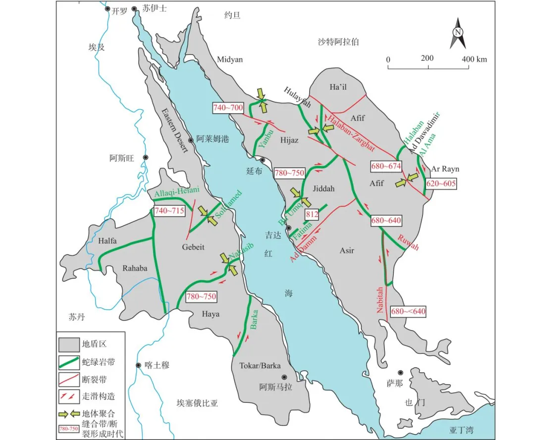
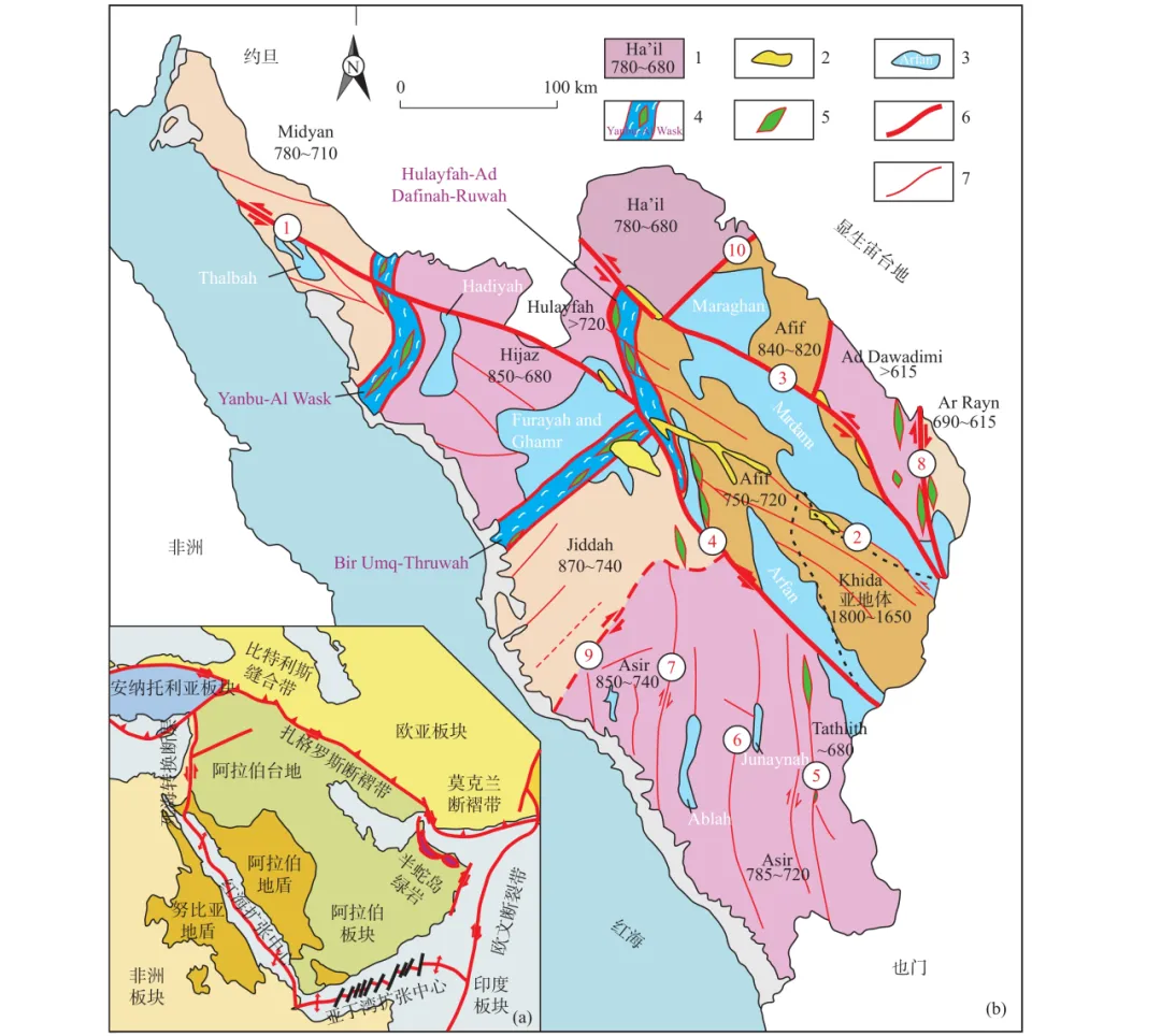
Recent work on the Al Amar-Halaban suture in the Arabian Shield suggests a different approach: build competing hypotheses that are consistent with geological history, then test them with gravity, magnetics, surface waves and MT. Rather than declaring one model optimal, the workflow progressively narrows the admissible model space by falsifying explanations that cannot satisfy independent observations.
GAIA Exploration follows this work because the value of exploration AI is not to generate an answer faster. Its value is to connect geological knowledge, probabilistic constraints, multisource data and physical tests so that each judgment has a traceable basis and every model remains open to challenge.
Why inversion can smooth away critical structures
Geophysical inversion is underdetermined. A three-dimensional volume may contain tens or hundreds of thousands of cells, each with an unknown density, susceptibility, resistivity or velocity, while the number of surface measurements is far smaller. Different subsurface configurations can therefore produce similar observed fields.
Regularization removes part of this infinite family of solutions. Minimum-structure and smoothness constraints are popular because they select comparatively simple models and make calculations stable. The Earth, however, is not obliged to be smooth. Ore-controlling faults, lithospheric shear zones, magma conduits, alteration fronts and fluid pathways are often abrupt property boundaries. If resolution is inadequate or smoothing is too strong, a narrow, steep structure connecting a deep source to a shallow trap can be redistributed into a wide, shallow anomaly.
The question is consequently not which inversion has the smallest misfit. It is which geological history can explain several independent observations without creating contradictions in another physical field. Does a deep structure provide heat and fluid? Does the fault connect upward? Are reactive lithologies and traps present? Do the geophysical responses agree with mapped alteration, mineralization and regional tectonics?
GAIA treats these differences as information. The system should preserve plausible alternatives, show which observations support them and identify which evidence can reject them. AI is useful when it makes disagreement explicit instead of compressing every dataset into one attractive picture.
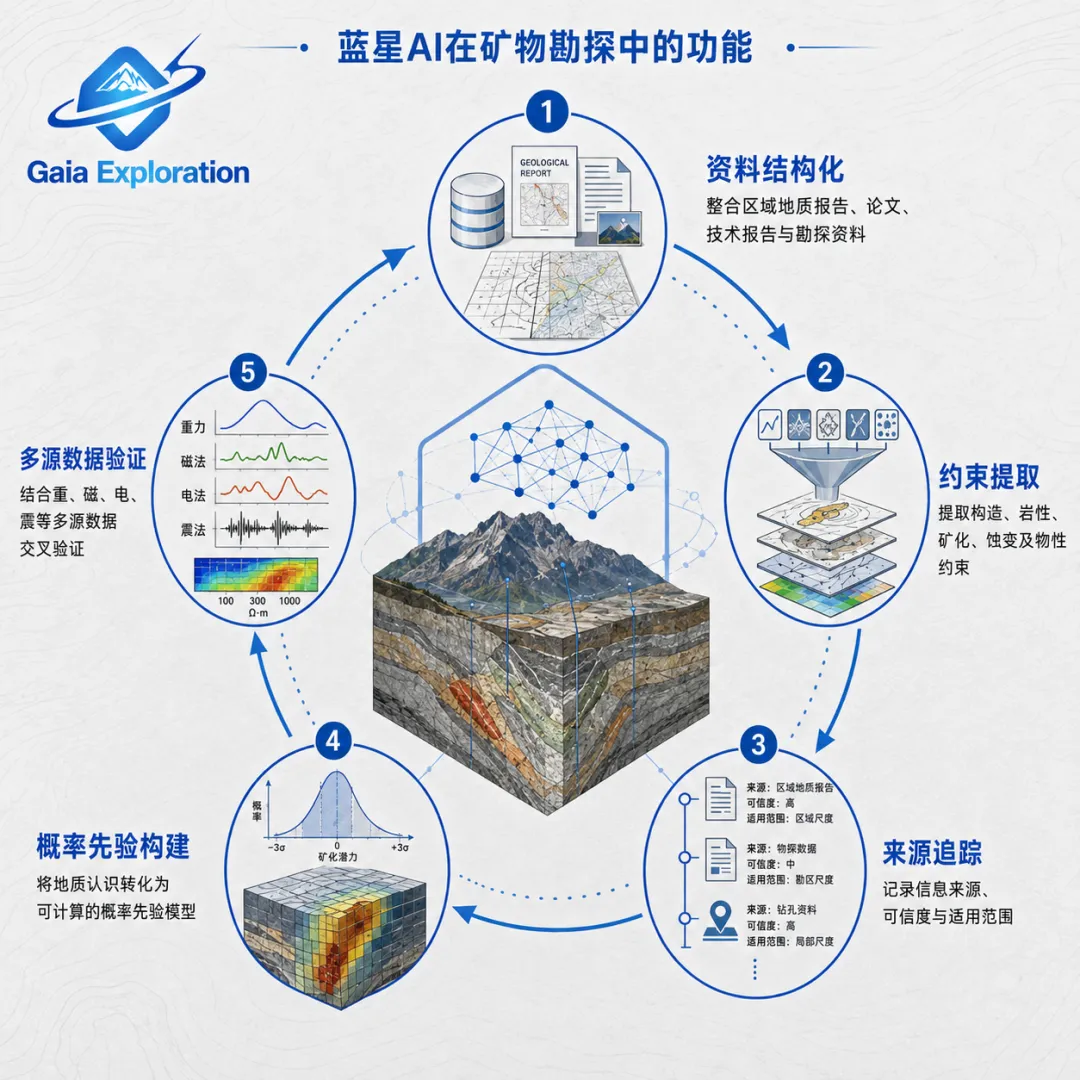
The LLM compiles geological knowledge; it does not “guess ore”
A significant feature of the cited workflow is that the large language model is deliberately constrained. It is not asked where the best ore lies. It acts as a controlled constraint extractor and geological compiler.
A structural geologist may describe arc magmatism, ophiolite emplacement, collision and suturing, strike-slip faulting and later metasomatism in natural language. The LLM maps those statements onto a predefined event framework, extracting only the geometrical, temporal and physical-property constraints that are actually supported.
Vague language must not be converted into false precision. “Near-vertical fault” does not authorize the system to impose a fixed dip of 75 degrees. “Possible deep metasomatism” cannot become one exact resistivity. Weak evidence requires a broad parameter distribution; only mapping, publications, geochronology or rock-physics measurements justify narrowing it. The maximum-entropy principle is valuable here: where knowledge is limited, uncertainty should remain visible rather than being manufactured away for computational convenience.
Every prior also needs provenance. The source of suture geometry, intrusion width, density, shear-wave velocity and resistivity should be recorded, together with whether a value is measured, regionally inferred or empirical. GAIA applies the same engineering discipline to geological reports, technical studies, papers, historical exploration files and existing geophysical or geochemical datasets: structure the information, extract constraints, preserve sources and confidence, construct probabilistic priors, and only then proceed to multisource testing.
Four fields expose geological “disguises”
The Al Amar-Halaban study constructed a fertile deep corridor as a test hypothesis. “Fertile” does not mean a mineable orebody at 15–40 kilometres depth; it means a tectonic-thermal-fluid system capable of supplying heat, material and pathways to shallower mineral systems. In the synthetic setup, the corridor had a joint signature: shear-wave velocity approximately 3–6% lower, conductivity about six times higher between roughly 15 and 40 kilometres, plus corresponding density and magnetic responses.
The researchers then deliberately built four barren rivals. Their geology differed from the fertile corridor, but each could imitate it in one or several datasets.
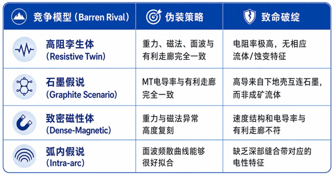
This experiment demonstrates that a dataset may be correct while the interpretation drawn from that dataset is wrong. A resistive twin can pass gravity, magnetic and surface-wave tests and is difficult to reject without MT. Conversely, MT can identify a conductor but cannot prove that the cause is mineralizing fluid, because interconnected lower-crustal graphite may look electrically similar. MT is an important constraint on deep fluids, not a sufficient condition for fertility.
Discrimination comes from joint testing. Gravity responds to density, magnetics to magnetic structure, surface waves to shear-wave velocity and MT to electrical properties. An inadequate hypothesis may satisfy one, two or even three fields. Satisfying all four, while remaining consistent with the same tectonic history, is much harder. In the synthetic experiment, gravity, magnetics and surface waves still failed to reject the resistive twin; MT alone failed to reject graphite. Only the four-field combination rejected all prescribed barren rivals.
This changes the meaning of an anomaly. The decisive criterion is no longer the strength of one magnetic high or the magnitude of one resistivity low. It is whether several physical parameters form a stable, mutually supportive relationship. In GAIA’s workflow, datasets should audit one another: a model that explains magnetics but contradicts conductivity loses weight; a model that explains a conductor but conflicts with density, velocity or regional structure cannot survive merely because one map “looks prospective.” The key capability is management of competing hypotheses and cross-validation of evidence.
When data reject a model, how should it change?
A method that works only on synthetic data has limited practical value, so the study also tested the priors against public real-world observations. The initial magnetic prediction did not encompass the observed magnetic field; the joint robust Mahalanobis distance reached 1.52 times the rejection threshold. The real data clearly rejected the original model.
The researchers did not simply tune susceptibility until the curve fitted. They returned to geological cause. Real arc crust appeared to contain magnetic intrusions more densely than the idealized model, producing stronger spatial variability. A named correction kept the susceptibility prior unchanged and adjusted only intrusion density, from about one to about three bodies per 1,000 km². After correction, the observed magnetics fell within the predicted range and the revised model remained subject to independent gravity and surface-wave tests.
The important result is not that a parameter changed from one to three. It is that each change must correspond to an intelligible geological reason. GAIA applies the same standard: record which data rejected a hypothesis, the scale of the conflict, the geological concept that changed, and whether the correction remains compatible with other fields. The output becomes a hypothesis–evidence–rejection–correction–retest chain rather than a single prospectivity map. Verified and rejected models can then accumulate as reusable geological knowledge.
Where should the next exploration budget go?
Repeated falsification does not make the subsurface unique, but it makes the remaining uncertainty more explicit. Is the dip of the deep suture constrained? Is the 15–40 kilometre conductor continuous? Does the three-dimensional velocity structure vary laterally? These unresolved variables should determine which data are acquired next.
The conventional sequence is “survey, invert, interpret.” An uncertainty-led sequence begins by asking which unknown currently controls the geological decision, then selects the survey most likely to reduce it. If deep electrical structure is the key issue, another MT profile may add more value than denser magnetics. If velocity architecture is disputed, surface waves or another seismic method may deliver the greater information gain. Exploration design shifts from collecting more data to collecting the most decision-relevant data.
For GAIA, this is the step from analysis tool to exploration decision system. AI should not only rank places of interest; it should identify the most credible current hypothesis, the variables that remain unconstrained and the expected information gain from the next investigation. Limited budgets, survey lines and engineering work can then be directed toward the observations that reduce the most consequential uncertainty.

Conclusion: putting AI inside the exploration decision chain
The principal lesson is not merely that an LLM entered geoscience or that gravity, magnetics, surface waves and MT were placed in one framework. It is that AI creates value when it connects knowledge, hypotheses, physical testing and the next decision.
GAIA is building a geological intelligence decision system for real projects: source structuring, constraint extraction, multisource validation, model correction and deployment of the next exploration program. The commercial questions are practical: where should capital continue to be committed, why is that direction justified, and which next dataset or engineering action will most efficiently test the case?
The goal is not to replace geology with AI, but to amplify geological judgment; not to produce a prediction in isolation, but to help a project choose its next move. By turning expert reasoning into a traceable, testable and reusable capability, geoscience AI can reduce unproductive expenditure and bring every exploration dollar closer to information that genuinely changes the underground decision.