Prospectivity, exploration targets and mineral resources
Establish the essential boundaries: a model score is not an orebody, a target is not a resource, and a resource does not automatically become a mineable reserve.
Read the fundamentalsThis is not a glossary of algorithms. It is a knowledge system for real exploration decisions—explaining how data become evidence, how models form subsurface hypotheses, how targets are ranked and how each judgment should be tested in the field.
Geological question—available evidence—analytical method—deliverable—validation boundary
Establish the essential boundaries: a model score is not an orebody, a target is not a resource, and a resource does not automatically become a mineable reserve.
Read the fundamentalsDifferent datasets answer different questions: geochemistry traces material, geophysics maps spatial structure, and geological constraints return anomalies to their mineral-system context.
View the data evidence chainTest the model against data evidence, metallogenic theory, geological mechanisms and physical laws, producing a traceable basis for every judgment.
Understand the core principlesStarting from weak surface anomalies, infer relationships among structures, hydrothermal fluids, alteration and mineralization in three-dimensional space and geological time.
Explore subsurface inferenceThe best hole is not merely the one most likely to intersect mineralization; it is also the test that most effectively reduces critical uncertainty.
View the decision workflowAI handles scale and complexity; geological experts own hypotheses, constraints, field judgment and decisions. Both success and failure enter the feedback loop.
View the evidence levelsExploration decisions follow a continuum of evidence. AI can organize evidence faster, identify nonlinear relationships and generate subsurface hypotheses, but it cannot bypass engineering validation or convert a probability score directly into a resource or reserve.
Multimodal integration is not simple map stacking. Each dataset should answer the question it is best suited to address, while mineral-system and spatial relationships connect the evidence.
| Data type | Primary question | Typical contribution | Limitations |
|---|---|---|---|
| Regional geology and structure | Where could a deposit form, and what system controls it? | Metallogenic belts, magmatism, fault pathways, stratigraphy and contacts | Map scale and age resolution constrain deep interpretation |
| Remote sensing and DEM | What alteration, lineament and geomorphological clues occur at surface? | Rapid regional screening, iron-oxide/clay anomalies and structural interpretation | Cover, vegetation, weathering and spatial resolution can introduce ambiguity |
| Geochemistry | Which element associations reflect material sources and mineralizing processes? | Primary and associated elements, front/rear halos and anomaly associations | Transport, secondary enrichment, sample medium and detection limits affect interpretation |
| Geophysics | Where might subsurface structures, lithologies or mineralized bodies occur? | Magnetic, density, electrical, chargeability and deep geometric constraints | Inversion is non-unique and must be integrated with geology and geochemistry |
| Drilling and exploration works | Is the subsurface hypothesis supported by direct evidence? | Lithology, alteration, mineralization, grade, thickness and structural relationships | Drilling samples a limited volume; spatial extrapolation remains uncertain |
| Historical reports and mine records | What work was done, and which interpretations succeeded or failed? | Reconstruct exploration history, constrain models and identify inconsistencies and risks | Data quality, coordinates, standards and disclosure conventions must be reviewed |
GAIA treats a model as a system for generating and testing hypotheses. Every output should state its geological basis, supporting evidence, conflicting evidence, uncertainty and next validation method.
Deposit type, metallogenic age, tectonic setting, magmatic-hydrothermal system, host rocks and alteration relationships determine which data associations are geologically meaningful.
Different regions, commodities, deposit subtypes, data densities and exploration stages require different model combinations. The system matches and integrates the methods suited to each task.
Even high-scoring targets must show data coverage, knowledge gaps and alternative interpretations so decision-makers know both where the opportunity is stronger and why uncertainty remains.
Geologists participate in constraint selection, anomaly interpretation, model review and field validation. As new evidence arrives, the model and geological hypotheses are updated together.
A 3D model describes subsurface geometry; the fourth dimension adds geological time and evolution. The aim is to explain how structures formed, how hydrothermal fluids moved, how alteration and mineralization overlapped, and what deep system may correspond to today’s weak anomalies.
AI creates value not by generating more points, but by focusing limited time, budget and fieldwork on validation actions with higher information value.
Integrate metallogenic setting, regional structure, remote sensing, terrain, known occurrences and public information to identify favourable areas and eliminate weakly supported ground early.
Output: prospectivity zones and critical data gapsGenerate comparable candidate targets from deposit models, anomaly associations, structural position, preservation conditions and uncertainty.
Output: target boundaries, rankings and evidence chainsAnalyse fault systems, fluid pathways, intrusions, lithological contacts and alteration zoning to form testable subsurface resource hypotheses.
Output: 3D hypotheses and directions of deep continuationCompare the cost, risk and information gain of sampling, geophysics, trenching and alternative drillholes to optimize the validation sequence and drilling plan.
Output: validation plan and recommended drill locations and sequenceGeological teams conduct reconnaissance, sampling, geochemical and geophysical surveys and drilling, recording supporting evidence, negative evidence and field conditions.
Output: validation results and basis for revising hypothesesNew data enter the model through Bayesian updating or other appropriate methods to reassess subsurface probability fields and the next engineering decision.
Output: updated models, targets and recommended actionsEfficiency note: 20–50-minute initial screening, 5–10-minute geochemical or geophysical analysis, and potential reductions of up to 50% in time and 60% in cost are indicative values for typical scenarios. Actual results depend on commodity, project stage, data completeness, computational task and field conditions and are not universal delivery commitments.
AI should answer different questions at different project stages. Greenfield work narrows the search space; brownfield work focuses on deep and near-mine additions; investment due diligence exposes risk earlier.
Build a regional metallogenic logic and generate first-pass validation targets where historical work is limited and data are sparse.
Reinterpret deep extensions, blind orebodies and structural repetition around known orebodies, mineralized zones or historic mines.
Check consistency and rank risk across mineral rights, historical reports, resource logic, infrastructure and validation cost.
Connect AI targeting, field validation, mineral-right interests and project value creation through staged decisions and partnership mechanisms.
The cases below focus on geological context, AI interpretation, subsurface hypotheses and validation value. Project conclusions still require supporting engineering data.
Greenfield targeting of a porphyry–skarn copper-gold system.
Use: provide a targeting basis for high-resolution magnetics, 3D induced polarization and engineering validation.
Inference of concealed shear-zone gold under sparse data and extensive cover.
Use: demonstrate the ability to form testable targets in data-sparse areas with substantial surface cover.
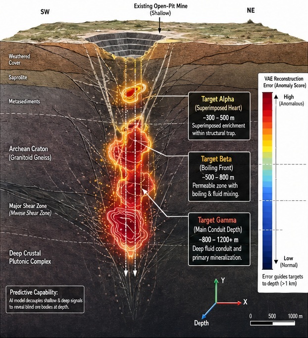
Interpretation of a deep porphyry copper-gold system beneath shallow gold mineralization.
Use: support deep-resource inference, brownfield resource growth and optimization of subsequent drilling directions.
Terms such as prediction, inference, target and prospectivity have explicit evidence boundaries in this Knowledge Center. The closer a conclusion is to resource disclosure or an investment decision, the more it requires direct engineering evidence and independent professional review.
GAIA Exploration is building an AI-driven mineral discovery system for the global critical-minerals industry. It is not a single software package or prediction model; it connects multimodal geoscience data, mineral-system modelling, physics-constrained AI, subsurface probability inference, drill optimization and expert geological validation in one workflow.
No. AI outputs evidence-based prospectivity, anomaly interpretations, subsurface resource hypotheses and target priorities. Every target must be tested through geological review, sampling, geophysics, trenching or drilling. A responsible system should also report uncertainty, alternative interpretations and recommended next validation work.
Physics-constrained AI introduces interpretable constraints—including mineral systems, tectonic evolution, hydrothermal fluids, lithology, alteration and geophysical responses—so outputs pursue both data fit and consistency with geological mechanisms and physical laws. At GAIA, geological constraints take priority over model output.
A phased analysis is possible, but every conclusion must be calibrated to data quality. Regional geology, remote sensing, public information and limited field data can support preliminary hypotheses while identifying missing data, epistemic uncertainty and the most informative additional work. Sparse data do not prevent analysis, but they do not justify overconfident conclusions.
An exploration target is a spatial area prioritized for testing; it is not a discovered orebody, mineral resource or reserve. Resources and reserves can be determined only after the applicable exploration work, sampling and analysis, geostatistics, techno-economic evaluation and reporting requirements are met. AI prediction can optimize the validation sequence but cannot replace compliant resource estimation.
AI can place candidate drill locations, engineering cost, geological probability and information gain in one decision framework, then compare how much each hole would reduce subsurface-model uncertainty. New drilling data update the probability model and subsequent hole sequence. An optimal plan considers not only the chance of an intersection in one hole, but also the learning efficiency and budget constraints of the entire program.
No. GAIA uses an AI + HI (Human Intelligence) approach: AI handles large-scale data processing, pattern discovery, scenario computation and consistency checks; geologists build hypotheses, select constraints, interpret anomalies, review results, validate in the field and make final decisions. High-quality exploration comes from a closed loop of algorithms, geological experience and engineering feedback.
Validation normally progresses in stages according to risk and cost: desktop review, field reconnaissance, surface or stream-sediment sampling, denser geophysical and geochemical surveys, trenching and drilling. Validation aims not only to prove a model correct, but also to identify incorrect hypotheses early. Both successful and unsuccessful results feed back into the system to update subsurface probability fields and recommended next actions.
If you have a licence boundary, historical reports, remote-sensing imagery, geochemical or geophysical data, or drilling records, GAIA can help organize the evidence, identify critical data gaps and design a phased validation plan.