When mineral exploration begins in an unfamiliar country, early research must first answer three questions: what mineral systems may have developed in the region, what the existing evidence can support, and what is most worth committing resources to verify next. Mineral-occurrence locations and anomaly maps can provide clues, but they only become useful for exploration deployment when placed back into tectonic evolution, magmatic activity, host stratigraphy and mineralizing processes. In regions where public information is fragmented and the history of research is uneven, this work depends especially on systematic source organization and professional review.
GAIA Exploration recently used Myanmar as the subject of an application test centered on a real mining-investment question: without first selecting a particular mineral right and without sending a geological team into the field, could public sources be used to build regional geological understanding suitable for professional discussion and identify priority areas worth further validation? The study used a combination of one general-purpose large language model and one specialist geoscience agent, pairing ChatGPT 5.6 Sol with the Gaia Senior Geologist Agent.
01From mineral-occurrence information to mineral-system understanding
The first challenge in the Myanmar study was the absence of a unified interpretive framework across dispersed sources. Regional structure, stratigraphy, magmatic activity, deposit descriptions and historical engineering records each capture a different side of the mineralizing process. Researchers from different periods may also classify and interpret the same deposit differently. Simply grouping mineral occurrences by commodity does not answer exploration questions about ore controls, mineralization stages or depth extensions.
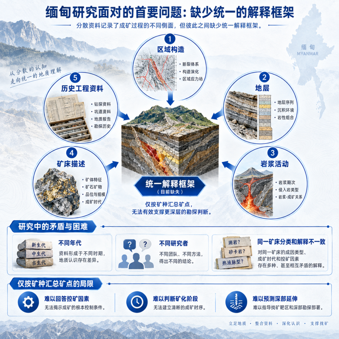
In this study, the Gaia Senior Geologist Agent helped organize document reading at the mineral-system level and compare interpretations around tectonic setting, fluid activity, host strata and mineralizing processes. The general model supported reading, information organization and comparison across sources, while the specialist agent supplied an analytical framework for geological questions, helping users distinguish information with exploration significance from information that still required verification.
The study examined several different analytical subjects, including gold deposits, skarn deposits, antimony deposits and lead-zinc deposits. Their ore controls and validation priorities differ. For a gold system, the question is whether structural activity provided migration channels and depositional space for mineralizing fluids. For a skarn system, analysis should consider not only mineral assemblages created by early contact metasomatism but also the spatial and temporal relationship between later hydrothermal alteration and economic mineralization. For antimony, regional fluid-transmitting faults need to be distinguished from local ore-hosting structures. For lead-zinc, the stratigraphic architecture should be used to judge whether favorable host horizons occur at different depths and whether they are continuous.
These differences mean anomalies cannot be ranked independently of geological context. Surface Au anomalies, fault distributions or mineral assemblages may serve as research clues, but they do not automatically equal economic orebodies. GAIA’s role at this stage is to help formulate testable subsurface hypotheses and advance the question from “what anomaly is here?” to “what geological mechanisms could explain it, and how should they be tested?”
In validation design, different hypotheses should also lead to different observation targets. If secondary structures are thought to be the main control, subsequent work should examine the relationship between structural geometry, kinematics and mineralization positions. If a favorable horizon is thought to extend to depth, more stratigraphic, structural or drilling constraints are required. This describes a method for deriving validation tasks from mineral-system understanding; it does not mean the remote study had already obtained such field evidence.
02How GAIA AI participated in source integration and geological analysis
Around these questions, the Gaia Senior Geologist Agent helped advance three core tasks: source integration, comparison of interpretations and evidence review. Source integration was not a matter of simply shortening documents. It organized relevant information from specialist papers, technical reports and historical mining records under specific geological questions. Comparing interpretations examined the observations and inferences on which different mineralization concepts depended. Evidence review went a step further by asking whether key figures, deposit classifications and regional conclusions could be supported by the original sources.
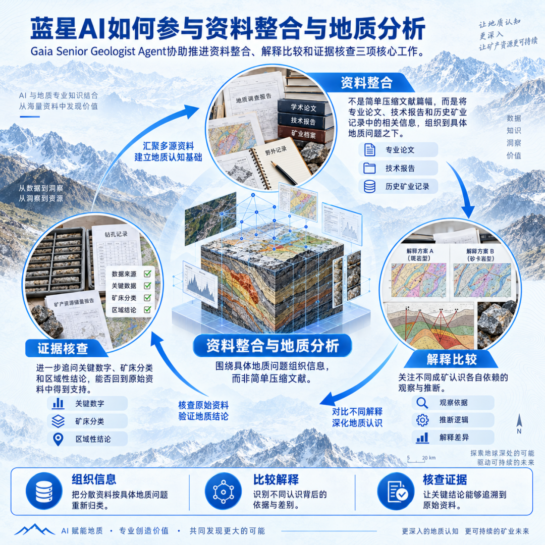
For example, when papers offered different interpretations of the same deposit, the analysis could not stop at choosing the more complete narrative. It had to compare the petrological, fluid-inclusion or isotope evidence cited by each paper and determine whether that evidence constrained fluid source, mineralizing conditions or mineralization timing. Different evidence types support conclusions to different degrees. New evidence may revise an earlier understanding, but it should not automatically be treated as more reliable simply because it was published later.
As the user continued to ask questions and the specialist agent assisted with review, some historical work quantities were corrected after tracing them back to the original literature. Some regional mineralization interpretations were marked for validation because the full original source could not be obtained. Other interpretations that were logically plausible but lacked direct evidence remained hypotheses. These specific changes show that AI’s value lies not only in organizing sources, but also in identifying information gaps and avoiding the presentation of inference as fact.
This collaboration also changes the relationship between users and AI. Users must continue to ask geologically meaningful questions and inspect the sources, reasoning chain and uncertainty in the agent’s output. The agent expands the range of information that can be handled and presents the grounds and disagreements behind different interpretations. GAIA’s specific value in this process is to connect professional problem organization, source comparison and repeated review so the analysis can deepen through new questions.
03Correcting judgments through evidence review
Exploration analysis is vulnerable to confirmation bias. When a study is framed as “proving that an area has potential,” faults, alteration and known mineral occurrences may all be placed into the same favorable interpretation while contradictory information is ignored. The test therefore required the AI to actively look for evidence that could overturn its own judgment and determine whether the conclusion was genuinely constrained by data.
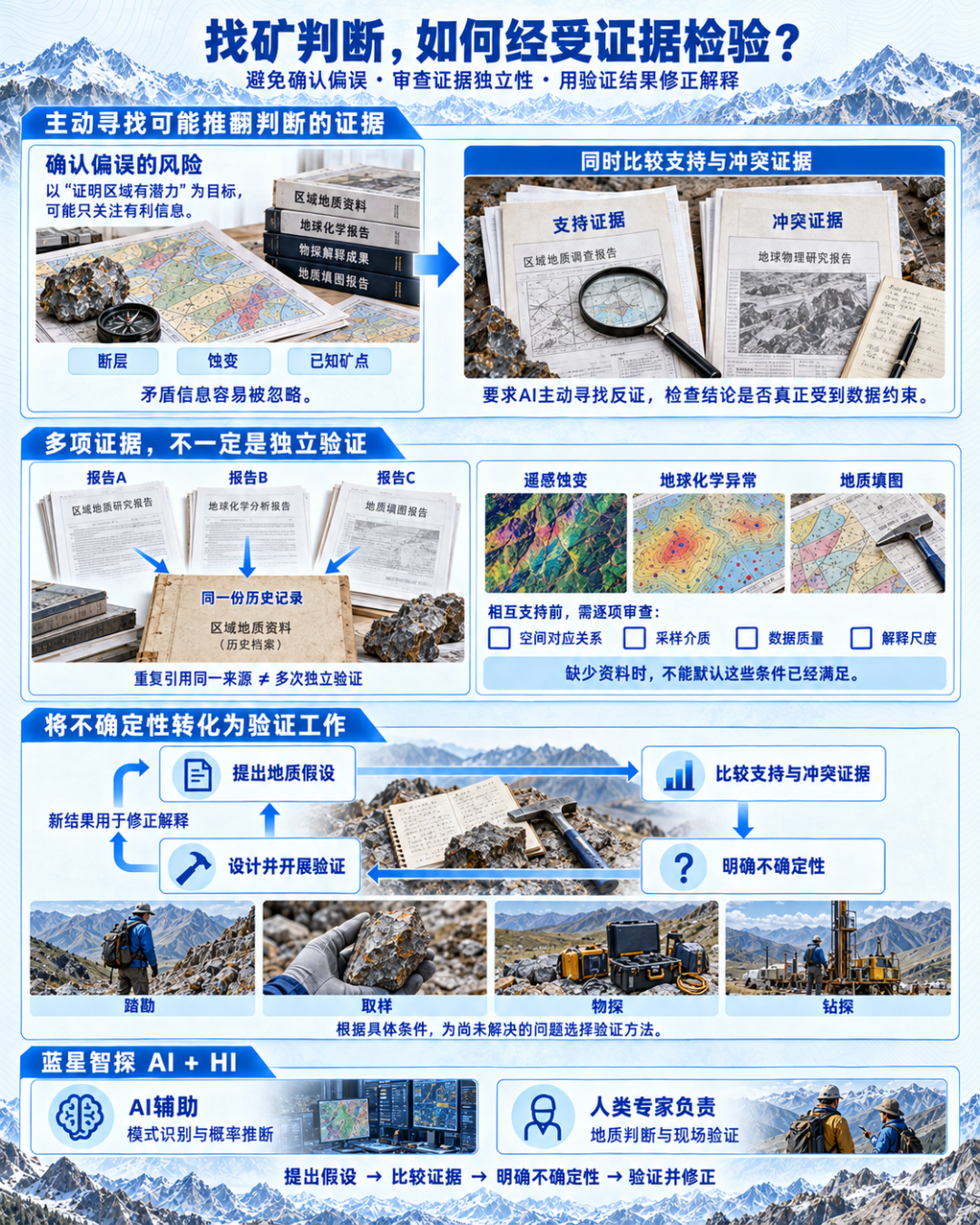
Professional review must also distinguish the number of evidence items from their independence. Several reports repeating the same historical record do not amount to several independent validations. Whether remote-sensing alteration, geochemical anomalies and geological mapping support one another depends on spatial correspondence, sampling media, data quality and scale of interpretation. These should be review checkpoints, not assumptions treated as satisfied when information is missing.
The resulting work logic is to formulate a geological hypothesis, compare supporting and conflicting evidence, state the uncertainty, and then design validation work. For unresolved questions, reconnaissance, sampling, geophysics or drilling can be arranged according to the particular conditions, with new results used to revise the interpretation. This is GAIA’s AI + HI method: AI assists with pattern recognition and probabilistic inference; human experts remain responsible for geological judgment and field validation.
04Building regional understanding from public sources that can continue to be tested
Through document reading, comparison of interpretations and repeated review, the study gradually narrowed broad regional information to a small number of priority areas worth further field investment. Progress meant moving from “lacking a systematic understanding of a country” to “being able to discuss major mineralizing conditions, identify evidence gaps and propose validation directions.” This result provides a starting point for the next stage, but it is not the same as discovering a deposit, estimating resources or completing an engineering feasibility assessment.
The test also had an important boundary: it did not call GAIA’s four proprietary model classes for greenfield exploration, deep exploration, drill optimization or 4D geological spatiotemporal inversion. The research relied on continued cooperation between a general model and a specialist agent to organize and analyze geological knowledge from public sources. The value demonstrated by the case should therefore be understood as an expansion of professional research capability, not attributed directly to the performance of a mineral-prediction model.
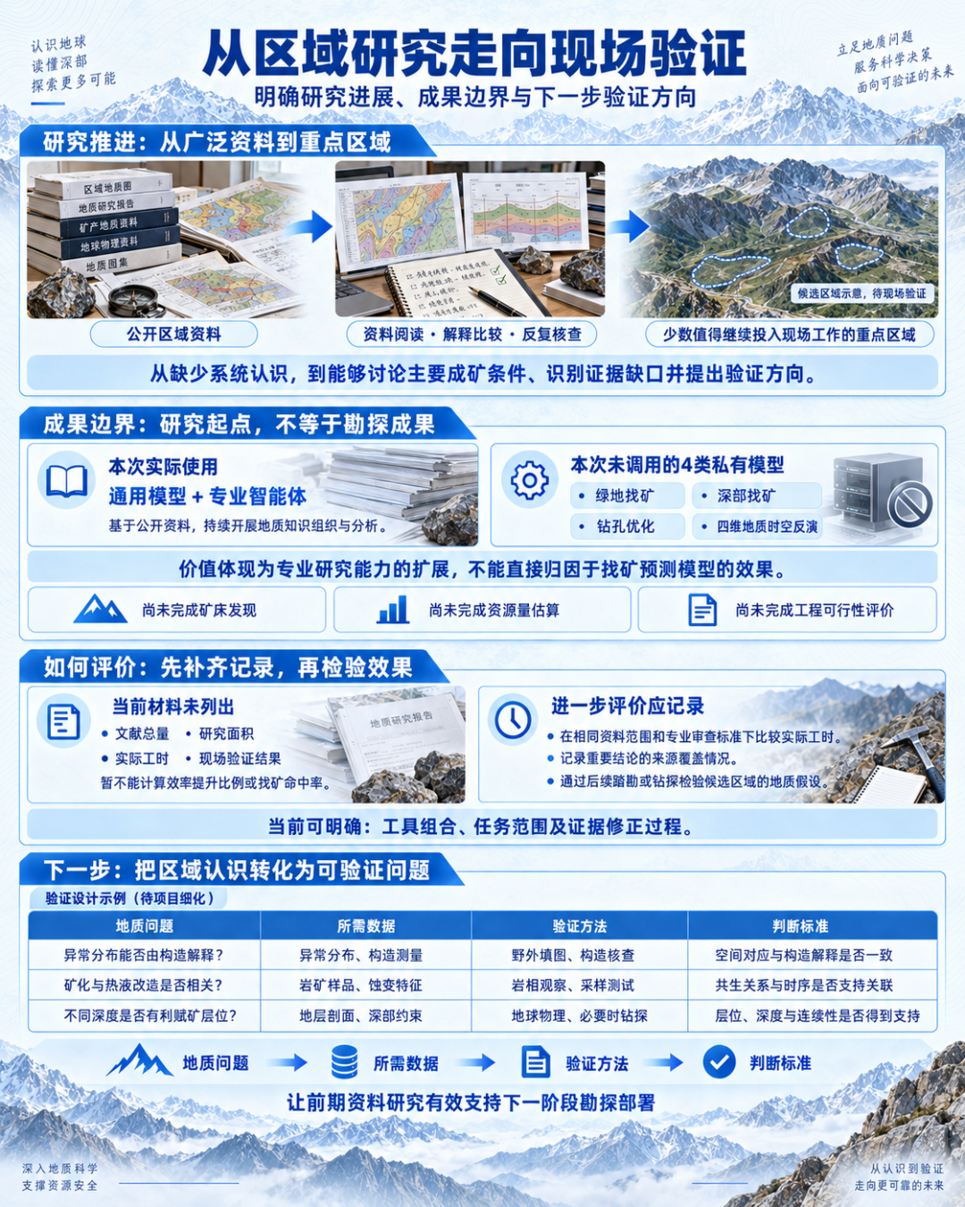
The available case materials do not state the total number of publications, research area, actual working hours or field-validation results. They therefore cannot yet be used to calculate an efficiency-improvement percentage or exploration hit rate. What can be stated is the tool combination, task scope and process of evidence correction. A further evaluation should compare actual working time under the same source scope and professional-review standard, record source coverage for important conclusions, and test the geological hypotheses of candidate areas through later reconnaissance or drilling.
For the next stage of geological work, regional understanding must continue to be translated into specific questions. Can the spatial distribution of an anomaly be explained by the existing structure? Is there a clear relationship between mineralization and hydrothermal alteration? Do favorable host horizons exist at different depths? Only by linking these questions to the required data, validation method and judgment criteria can early research effectively support exploration deployment.
05Professional knowledge becomes easier to access
Geologists’ responsibilities become clearer
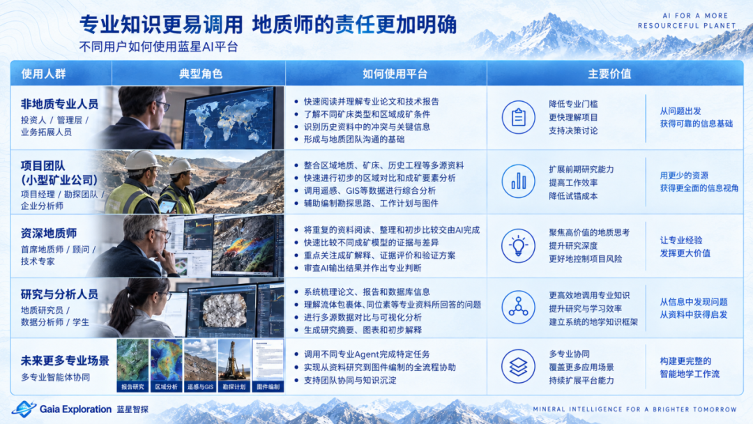
The test also raised a question worth discussing: how far can people without geological training advance a study with the help of an agent? At the source-research and preliminary-analysis level covered by this case, users can ask a specialist agent to read papers and technical reports, compare deposit types and regional mineralizing conditions, understand the questions answered by specialist evidence such as fluid inclusions and isotopes, and identify conflicts in historical records. This creates a basis for communicating with a geological team.
This means some professional knowledge can be called through clearer tasks and interactions. A general-purpose LLM provides reading, information organization, reasoning and cross-domain analysis. A specialist agent introduces geoscience knowledge structures, judgment frameworks, terminology and output requirements, bringing the analysis closer to the issues that concern senior geologists. Users still need to define the research purpose, inspect source material and know when to submit a question for review by the appropriate professional.
For small mining companies and project teams, this approach can expand early-stage research capacity. Senior geologists can delegate some repetitive reading, source organization and preliminary comparison to AI assistance and focus on mineralization interpretation, evidence evaluation and validation design. In the future, report research, regional analysis, remote sensing and GIS, exploration planning and map preparation can progressively be supported by different specialist agents, while geologists coordinate the questions, review results and make decisions.
Easier access to professional capability does not mean that a non-specialist has become a Competent Person, nor does it mean AI can replace field geology, core logging, sampling, QA/QC, drilling or resource estimation. GAIA aims to expand a team’s capacity to process information and organize research; responsibility for key geological interpretations and engineering decisions remains with professionals.
Gaia AI Platform
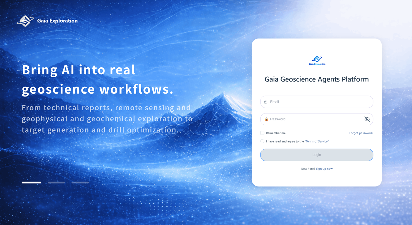
Bring agents into real geoscience workflows
The case above demonstrates one way to use a specialist agent, while Gaia AI Platform addresses a broader range of geoscience tasks. GAIA Exploration launched the Gaia Geoscience Agent Platform at China Mining on 10 September 2026, aiming to connect AI with geologists’ existing data, models, software and judgment systems so professional capability can operate within specific projects.
A geoscience agent can be understood as an AI work unit for a professional task. A geologist first defines the problem—for example, organizing historical reports, analyzing geochemical data, comparing several exploration targets or checking drillhole information. The agent then uses the project context to help select methods, call tools, organize analysis and form outputs. The platform emphasizes a sequence of understanding data, selecting methods, calling tools, analyzing, validating, creating maps, generating reports and proposing next steps, with professionals retaining final review.
According to the launch materials, the platform contains nine classes of specialist GeoAgents. Gaia Report Agent supports technical-report analysis. Gaia Geochem Agent, Gaia Geophysics Agent and Gaia Remote Sensing Agent respectively address geochemistry, geophysics and remote-sensing tasks. Gaia Targeting Agent and Gaia Drill Agent support mineral prospectivity, targets and drilling-related work. Gaia GIS Agent, Gaia Coding Agent and Gaia Mining Engineer Agent support spatial data, code and data processing, and selected mining-engineering tasks. The platform’s overall capability should be distinguished from the scope of this case, which used the Senior Geologist Agent.
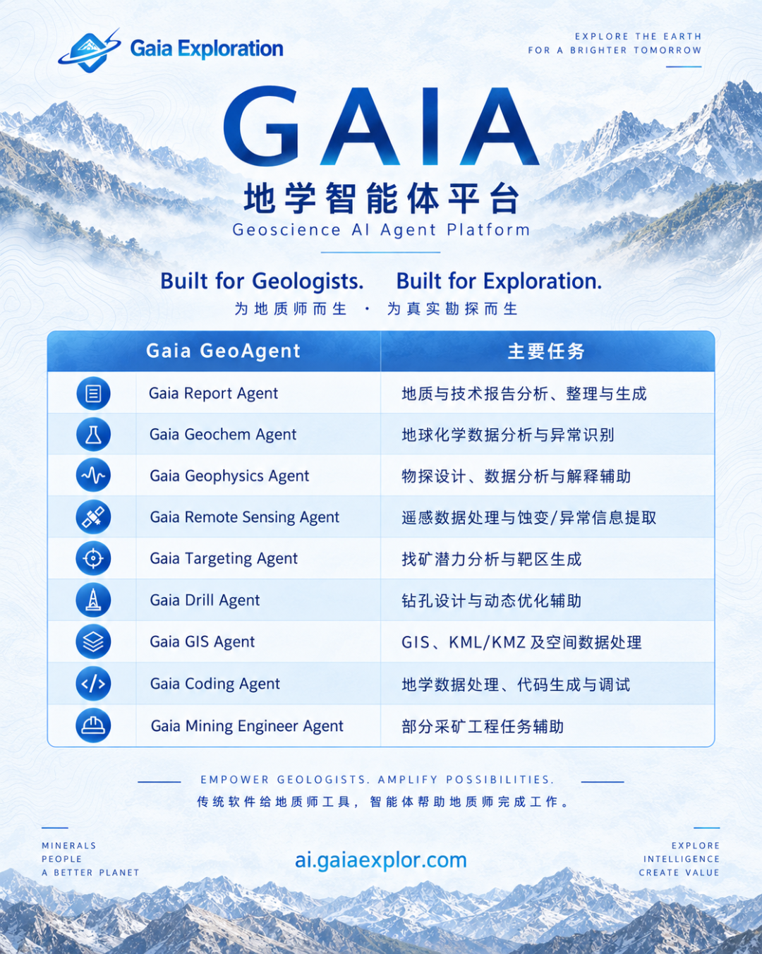
These tasks form a continuum. Report research can organize project background; geochemical, geophysical and remote-sensing analysis can test the resulting ideas; GIS processing helps structure spatial information; and target comparison brings different evidence into the questions that need later validation. The platform aims gradually to create a workspace that understands project context, allowing specialist agents to share the information they need and reducing repeated uploads, repeated explanations of background and repeated reorganization of results when tasks change.
For geologists and exploration managers, the platform can support source research, specialist data analysis and preparation of deliverables, leaving more time for mineralization interpretation and technical review. For mining companies and mineral-rights holders, the emphasis is on organizing project materials, comparing research directions and defining subsequent exploration needs. For resource investors and small project teams, agents can help interpret technical reports, identify questions that still require verification and improve communication with professional geological teams.
Gaia AI Platform currently focuses on real geoscience and mineral-exploration tasks and emphasizes collaboration among specialist agents, project data and tools. Its goal is to deepen application within workflows over time, not to describe an evolving capability as a complete system that already covers the entire mining lifecycle. A user can begin with one report that needs checking, a dataset that needs interpretation or a geological question that needs validation, then judge whether the agent helps the project reach clearer understanding and a clearer next action.
This is also GAIA’s AI + HI principle: AI is responsible for pattern recognition and probabilistic inference; human experts are responsible for geological judgment and field validation. GAIA does not make black-box “deposit predictions.” It builds testable subsurface hypotheses from data, geology and human judgment to help teams make earlier decisions and reduce exploration risk.
Visit Gaia AI Platform to learn about the platform and its professional geoscience applications:

From understanding documents to understanding a mineral district
The Myanmar case shows that combining a general-purpose LLM with a specialist geoscience agent can help researchers start from dispersed public sources, organize regional understanding, compare mineralization interpretations, review critical evidence and gradually clarify directions worth further validation. For mining teams, the value of this way of working lies in knowing more clearly what the available information can support and what the next exploration investment should resolve.
Geological work always advances under uncertainty. AI can expand the range of materials processed and analyses undertaken, but research quality still depends on recognizing the conditions under which evidence applies, confronting conflict among different interpretations and revising judgments when new data arrive. As agents take on more repetitive work, the role of geologists in asking good questions, designing effective validation and accepting professional responsibility becomes more concentrated.
The shift from “help me write a geological report” to “work with me to understand a mineral district” is not merely a change in output format; it marks a deeper level of AI participation in professional work. Connecting source organization with geological interpretation, and geological hypotheses with field validation, is what it means for geoscience agents to enter real production workflows.