Why should a buried copper-zinc deposit be explained by a seafloor volcanic event that occurred about 380 million years ago?
Because a VMS (volcanogenic massive sulfide) deposit is not an isolated mass of ore. It is the preserved record of an ancient seafloor volcanic-hydrothermal system.
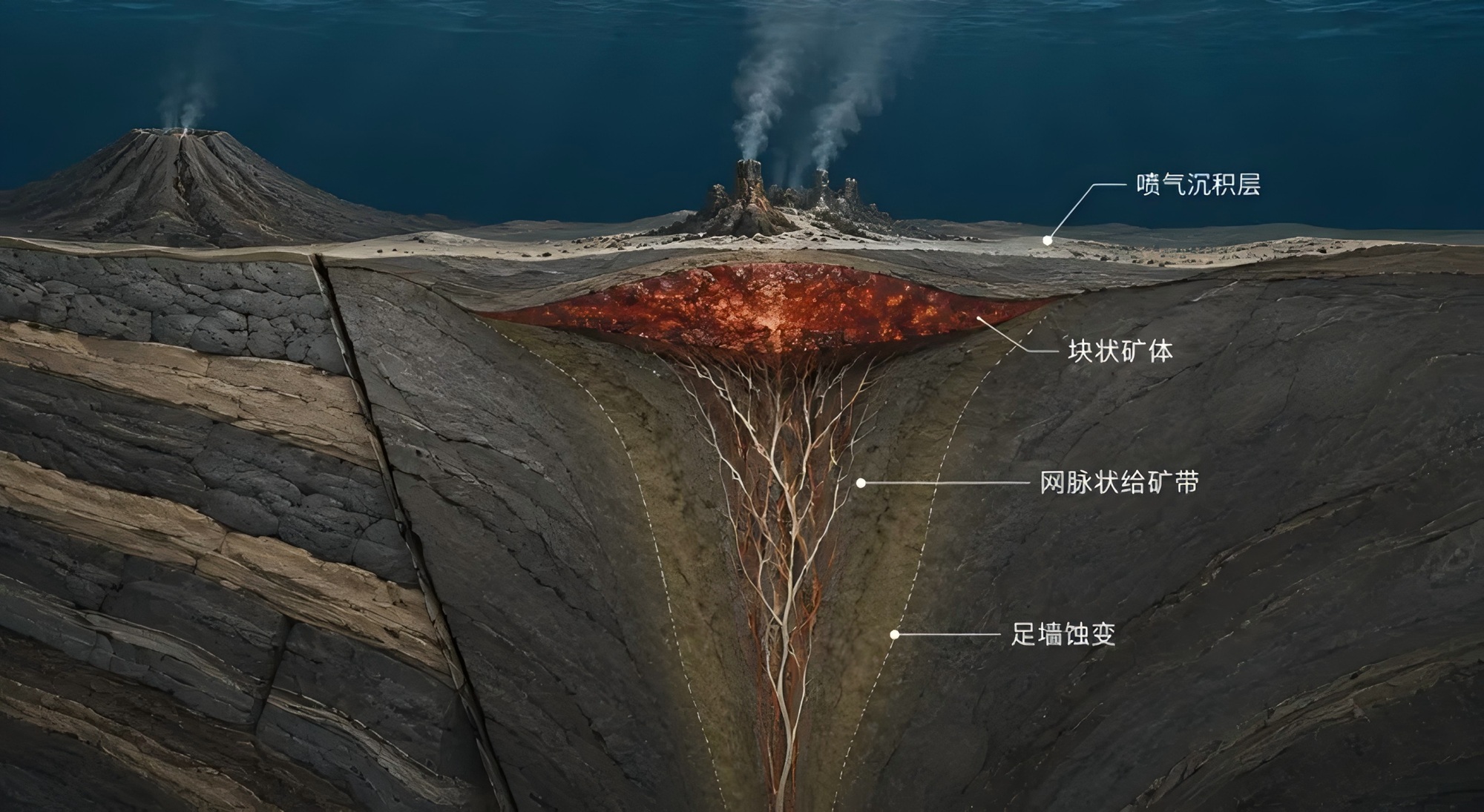
Magma provides the heat source. Seawater circulates downward along faults, leaches copper, zinc, lead, gold, silver and other metals from volcanic rocks, and then rises through hydrothermal pathways. When metal-rich fluids mix with cold seawater, sulfides precipitate rapidly, forming a massive sulfide body and an underlying stockwork feeder zone.
The USGS global database contains 1,090 VMS deposits and occurrences. Statistics for 432 Kuroko-type VMS deposits show a median ore tonnage of about 1.5 million tonnes, with median grades of approximately 1.3% Cu and 2.0% Zn.
VMS systems can form high-grade polymetallic deposits, but the ore bodies are commonly lens-shaped, stratiform or irregular massive bodies and may later be modified by folding, faulting and metamorphism. The real difficulty is not simply detecting an anomaly; it is deciding whether the anomaly belongs to the same mineralizing system.
Gaia Exploration does not use a single heat map to declare “there is ore here.” It organizes regional structure, volcanic stratigraphy, alteration, geochemistry, geophysics and historical drillholes into a target evidence chain that can be compared, explained and updated. Before drilling, can AI help a geological team decide which anomalies genuinely deserve priority testing?
PART 01
VMS exploration: the challenge is not detecting anomalies, but recognizing the mineral system
Electromagnetics, gravity, geochemistry, remote sensing and spectroscopy can all detect anomalies, but every single anomaly has multiple possible explanations. A strong conductor may be massive sulfide, graphite-rich strata or a water-bearing fault. Sericitization may be hydrothermal or regional metamorphic. A surface copper anomaly may also be affected by weathering and transport.
A target can therefore be upgraded only if several questions are answered together: Is the region in a favourable extensional setting? Does the prospective horizon belong to a favourable volcanic-sedimentary assemblage? Is the anomaly close to a felsic volcanic dome, a synvolcanic fault or a key lithological interface? Do alteration, geochemistry and geophysics form a reasonable zoning pattern?
Only when multiple evidence types can be explained by the same geological logic should an anomaly be promoted to a priority target. This is the first framework Gaia AI establishes.
PART 02
From 350°C hydrothermal fluid to massive sulfide: how does the ore body form?
The core of VMS mineralization is the sustained coupling of seawater, volcanic heat, fault pathways and depositional space.
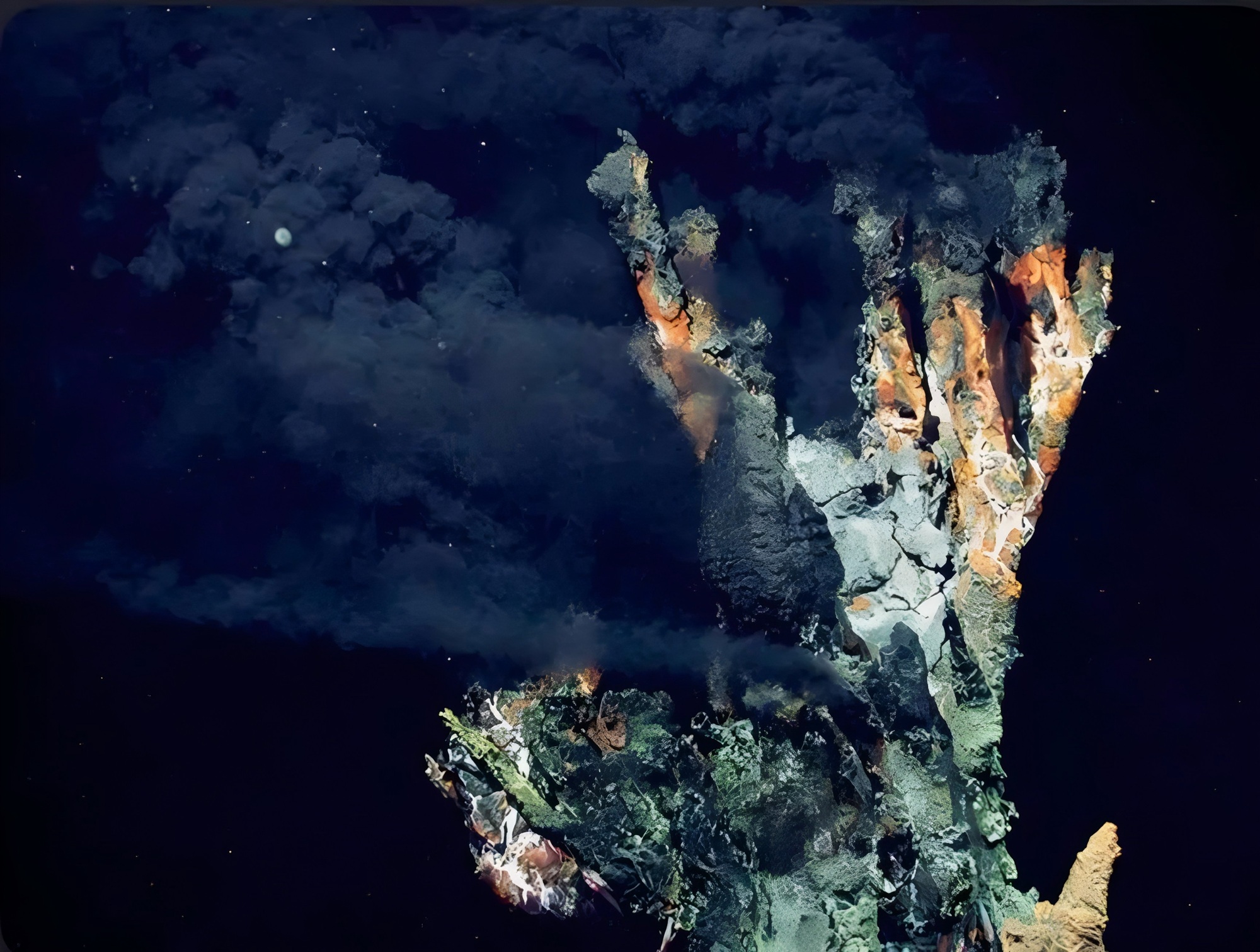
In back-arc extension or island-arc rifting, a shallow magma chamber provides high heat flow. Cold seawater infiltrates downward along extensional faults, is heated at depth to roughly 250–350°C, and reacts with basalt, rhyolite and volcaniclastic rocks, carrying copper, zinc, lead, iron, gold and silver.
As metal-rich hydrothermal fluid rises along synvolcanic faults and mixes with deep seawater near 2°C, temperature, pressure, pH and redox conditions change sharply and sulfides precipitate rapidly. High-temperature zones close to the feeder commonly develop chalcopyrite-pyrite stockworks. Sphalerite, galena and barite may increase in the upper massive ore body, while siliceous rocks, jasper and other exhalites may occur toward the top and margins.
Exploring for VMS today is therefore a process of reconstructing an ancient seafloor hydrothermal system from strata that have since been deformed, faulted and buried.
PART 03
A ~500 km metallogenic belt: why does the China–Kazakhstan Altai still matter?
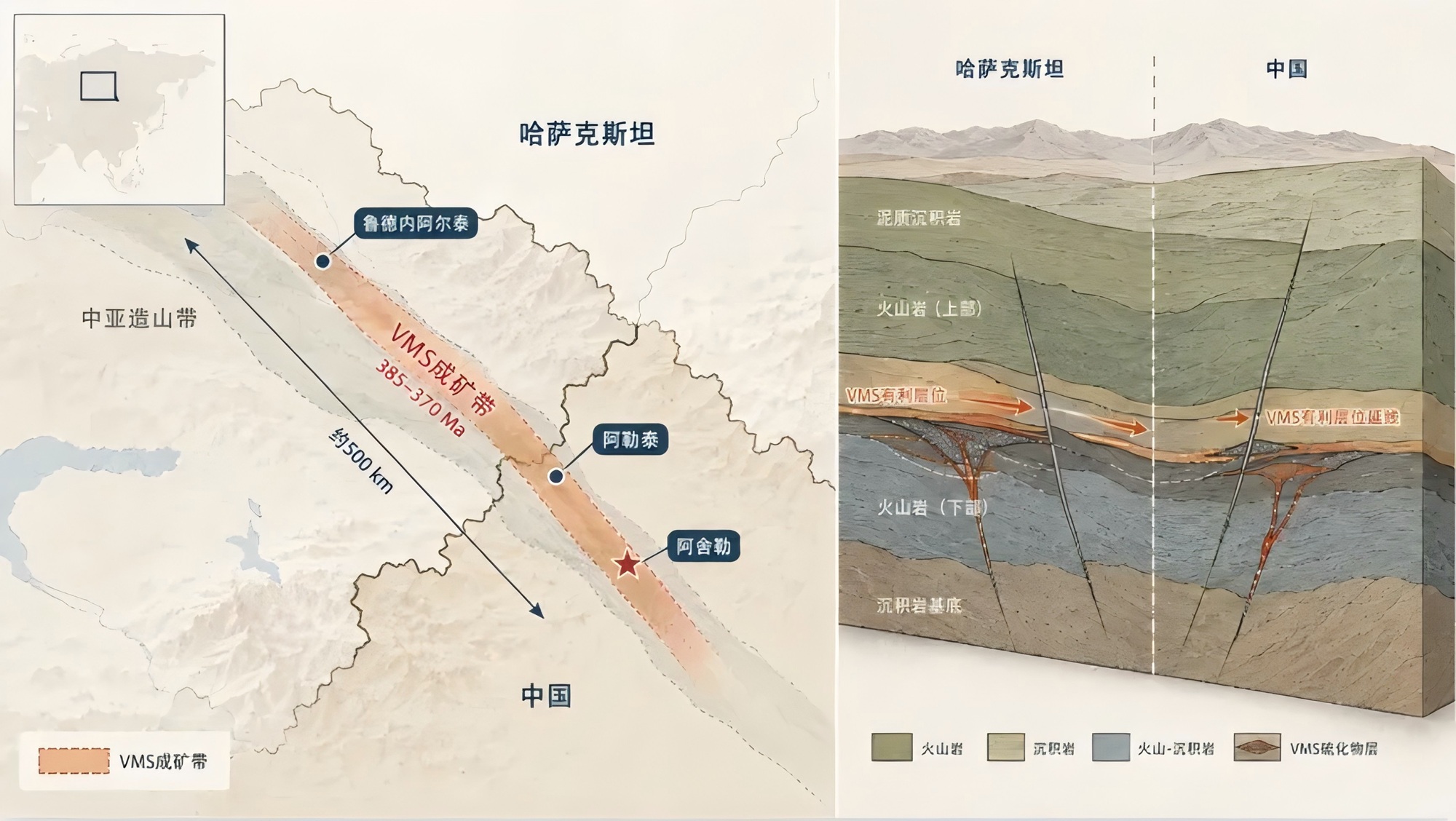
Northern Xinjiang in China and eastern Kazakhstan both belong to the Central Asian Orogenic Belt. Subduction of the Paleo-Asian Ocean, arc development and back-arc extension generated large volcanic-sedimentary basins and multiple episodes of seafloor hydrothermal activity.
The Rudny Altai VMS belt in Kazakhstan extends for about 500 km and locally reaches roughly 100 km in width. It is geologically continuous with the Devonian volcanic belt of the Chinese Altai. Around 385–370 Ma represents a regional mineralization peak, while the main mineralization age of the Ashele Cu-Zn deposit is approximately 388–387 Ma.
The source materials state that the Ashele copper mine has a processing capacity of about 7,000 t/d, reported contained copper of about 406,400 tonnes, and a copper grade of roughly 1.51%. New opportunities are increasingly expected at depth, on flanks, under cover and along extensions of the cross-border metallogenic belt.
Gaia AI can first identify favourable age windows, tectonic settings and volcanic-rock assemblages, then compress alteration, geochemistry, geophysics and drill data into a smaller number of testable targets.
PART 04
If the electromagnetic anomaly is strong, why not drill immediately?
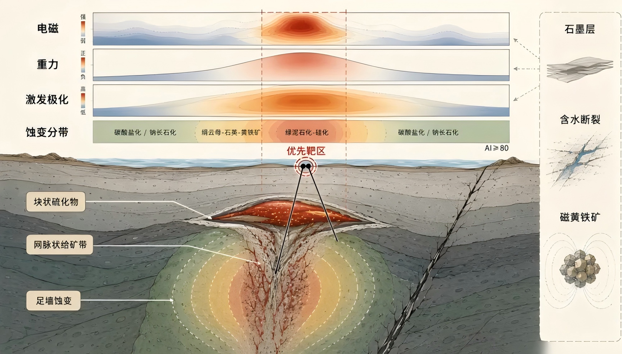
VMS ore is commonly conductive and relatively dense. Massive sulfide may have a density of about 3.5–4.5 g/cm³, noticeably higher than the roughly 2.6–2.8 g/cm³ of many host rocks.
Geophysics, however, only describes changes in subsurface physical properties; it does not automatically identify the source. Graphitic beds can conduct electricity, water-bearing faults can produce low resistivity, and pyrrhotite can generate magnetic anomalies.
Reliable targeting therefore requires joint constraints: electromagnetic methods locate conductors; gravity tests whether they are also dense; induced polarization tracks stockwork sulfides; geological mapping confirms stratigraphy and structure; geochemistry and spectral alteration help determine the direction toward the hydrothermal centre.
Footwall alteration may progress from peripheral carbonate alteration and albitization into a sericite-quartz-pyrite assemblage, with strong chloritization and silicification closer to the feeder. An Ishikawa Alteration Index near or above 80 may indicate strong hydrothermal modification, but it must still be interpreted against protolith and other evidence.
PART 05
When datasets do not “speak the same language,” Gaia starts with data governance
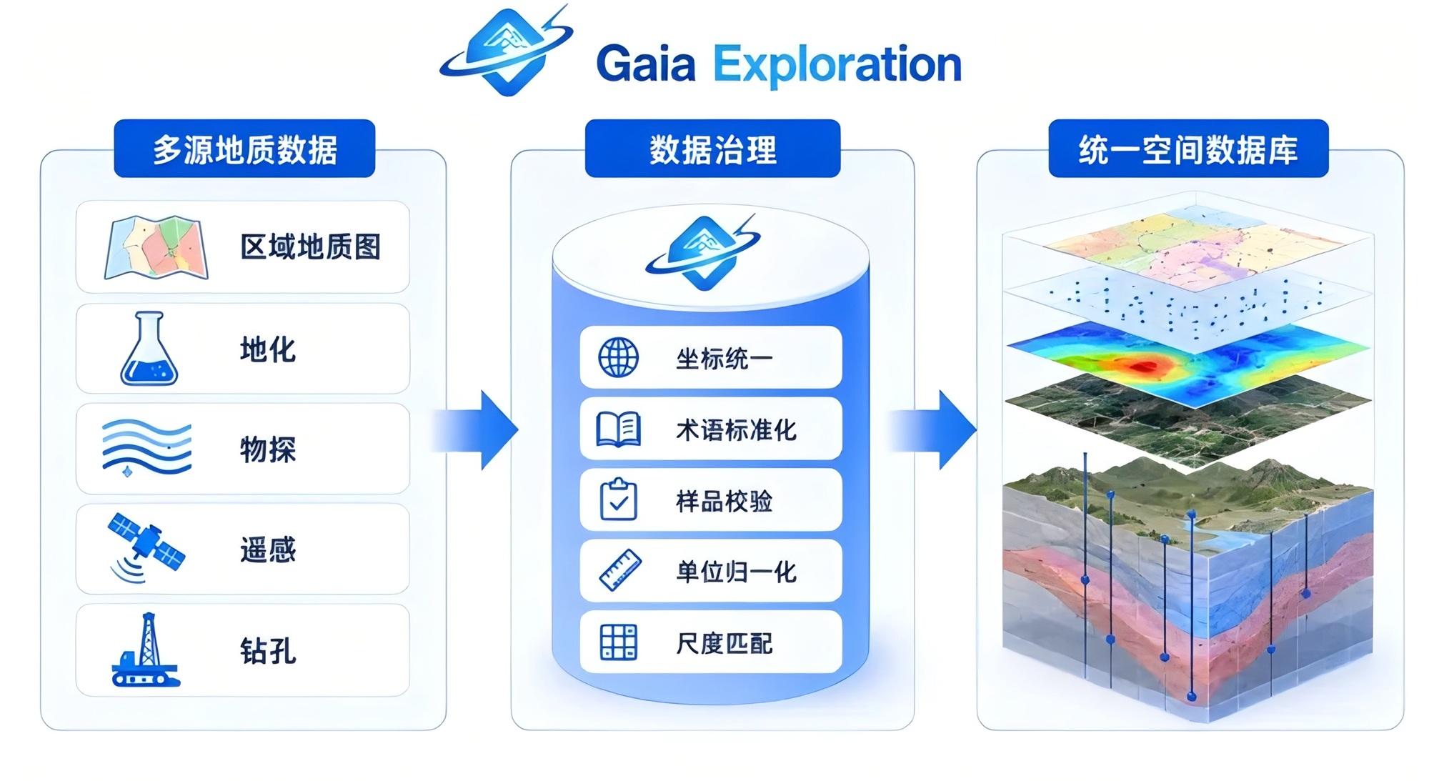
A VMS project may contain regional geological maps, geochemical data, geophysical inversions, remote-sensing and spectral datasets, and historical drillholes from different decades.
Coordinate systems, scales, terminology, elemental units and detection limits may all differ. If such data are simply overlaid, the result is often information accumulation rather than comparable geological evidence.
Before prediction, Gaia AI therefore aligns coordinates and spatial reference systems, normalizes stratigraphic, lithological, alteration and mineralization terminology, checks sample IDs, units and outliers, reviews drill collars, azimuths, dips and downhole intervals, and matches scales among regional maps, geophysics and drilling.
Gaia does not first ask the model to “guess where the ore is.” It first ensures that the model is seeing data that can be compared with one another and traced back to their source.
PART 06
How does Gaia AI turn scattered data into a target evidence chain?
After data governance, Gaia does not simply count how many anomalies overlap in one area, because different evidence types have different meanings in a VMS system.
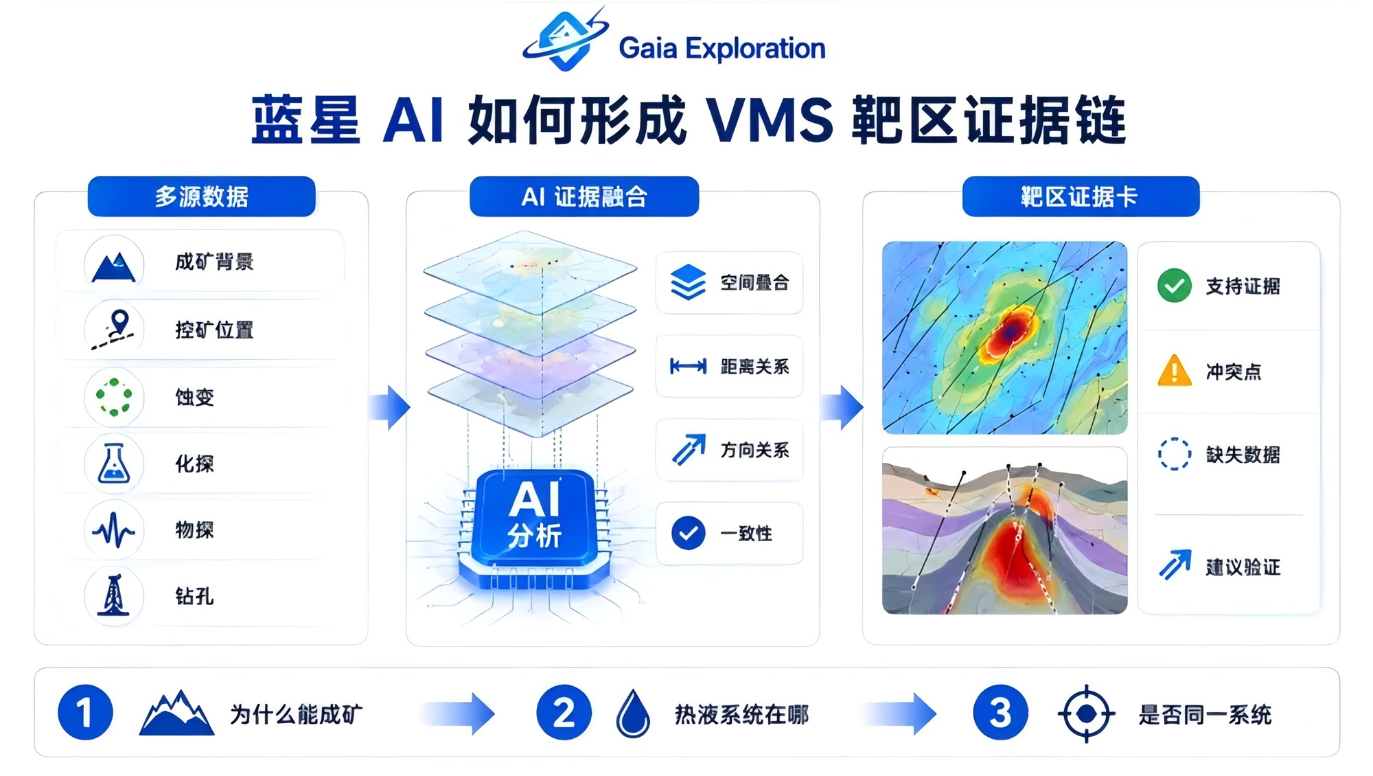
Step one asks, “Why could VMS form here?” Gaia identifies favourable extensional settings, Devonian–Carboniferous volcanic basins, bimodal volcanic assemblages and the distribution of known deposits, and filters out areas that clearly lack the required setting.
Step two asks, “Where might the hydrothermal system be?” Synvolcanic faults, the margins of felsic volcanic domes, eruptive centres, key lithological interfaces and local depositional depressions are used to constrain hydrothermal pathways and sites of ore deposition.
Step three asks whether the anomalies belong to the same system. Chloritization, sericitization, silicification, exhalites, Cu-Zn-Pb-Ag associations, EM conductors, local gravity highs and drillhole mineralization are placed in one spatial framework to analyse distance, orientation, overlap and zoning.
A conductor located near a favourable horizon and a synvolcanic fault, with alteration strengthening toward intense chloritization, ranks higher than an isolated conductor. If an old drillhole only intersects peripheral alteration but the indicators strengthen consistently in one direction, Gaia can flag the interpretation that the hole may be approaching the system without having crossed its centre.
Each target ultimately receives a traceable evidence card: what supports it, where evidence conflicts, what data are still missing, and how the next phase should test the hypothesis.
PART 07
AI changes the work sequence, not the rules of exploration
Conventional VMS exploration still requires regional studies, geological mapping, geochemistry, geophysics and drilling. AI does not remove these steps, but it can change their priority and sequence.
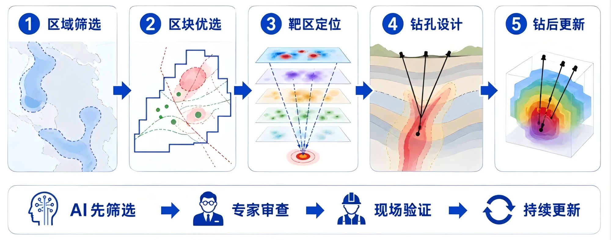
Gaia first screens favourable basins at the regional scale, then builds prospectivity zones around felsic domes, synvolcanic faults, key horizons and exhalites, and jointly constrains deeper targets with electromagnetics, gravity, induced polarization, geochemistry and spectral alteration.
At the drilling stage, Gaia breaks a target into testable hypotheses: which horizon should host the ore body, which peripheral markers a drillhole should encounter first, and which alteration and mineralization should strengthen as the feeder zone is approached. New drilling data then re-enter the model to refine 3D relationships and rank the next drillholes.
The work sequence shifts from “spread effort broadly, then eliminate” to “AI screens first, geologists review, fieldwork validates, and drilling continuously updates the model.”
PART 08
Conclusion: real AI exploration is not a red dot—it is an explanation of why a target deserves testing
VMS deposits formed in ancient seafloor volcanic-hydrothermal systems. Hundreds of millions of years later, geologists are working with residual evidence that has been buried, deformed and faulted.
What is scarce is not necessarily another data layer, but the ability to reorganize regional structure, volcanic stratigraphy, hydrothermal alteration, geochemical zoning, geophysical responses and historical drilling into a coherent mineral-system logic.
Gaia Exploration aims to make an anomaly more than a colour on a map, to make each target explain why it was selected, and to help the team know how to adjust even after a first drillhole misses.
AI handles complex relationships, quantifies relative favourability and exposes data gaps; geologists decide whether the model reflects real geological processes and how it should be tested.
AI screens first; geologists validate in the field. This does not replace conventional exploration—it gives each field campaign and engineering test a clearer direction.